
Washington Street Address Walkthrough
A street search in Washington begins with a parcel, not a guessed list of households. The assessor ties a physical address to a tax parcel and may show a taxpayer or owner. The map places that parcel beside others. The auditor or recorder holds deeds and plats, while a city permit system can add dated work records. These sources answer different questions: an assessor report is a current tax-roll lead, a deed records a transfer, and a Washington street directory gives a time-bound clue about an adult resident or business.
- Normalize the address, including direction, street suffix, unit, postal place, and ZIP. If the address is old, keep alternate street names or numbers in the search notes.
- Identify the Washington county and open its assessor or GIS site. Search the physical address, then save the parcel number, legal description, taxpayer name, and map location.
- Read the parcel report with care. Keep the site address separate from any tax mailing address, and treat the taxpayer as an ownership lead rather than a confirmed occupant.
- Use the map to select the street segment or nearby parcels where the county tool supports it. Note the layers and selection method used.
- Carry the parcel number and legal description to the county auditor or recorder. Search deeds, plats, and other recorded instruments by the fields the local portal supports.
- Search permits or code cases through the city or county that handled the work. An applicant or agent named in a permit is not automatically the owner or resident.
- For a past household, consult a library or archive for street and reverse directories, then compare the year with census, map, newspaper, or probate evidence.
Washington has no uniform assessor form or single statewide deed index. If an online result is missing, the next useful move is often a county counter, phone or mail request, public-records request, or archive check. Keep the search county-first even when a postal city suggests a different local boundary.
Washington Street Record Coverage
Washington street records sit with the county or city that created them. A useful first pass checks each source for its own date range and evidence type. A county property roll can identify a taxpayer; GIS adds location; the recorder documents transfers; and a city permit file may show a project or inspection. None is a complete roster of people at every address, which is why a street directory should be treated as one dated clue.
| Washington Record Set | Custodian | Useful Evidence | Access Route |
|---|---|---|---|
| Assessor property roll | County assessor | Taxpayer or owner, parcel, situs and mailing fields, value, sales history | County portal, counter, phone, or request |
| GIS parcel layer | County GIS or assessor | Parcel geometry, address points, zones, districts, and map context | Web map, GIS office, or export where offered |
| Recorded deeds and liens | County auditor or recorder | Grantor, grantee, recording date, legal description, instrument | Index, copy request, counter, or archive |
| Plats and subdivisions | County recorder or GIS | Lot, block, plat, road layout, and boundary descriptions | Legal or plat search, archive for older books |
| Tax roll | County treasurer | Parcel account and tax status; payer may not be an occupant | County tax portal, counter, or request |
| Permits and code cases | City or county department | Applicant, agent, project, inspection, violation, and dates | Local portal, department, or public-records request |
| Voter file or list | County elections office or Secretary of State | Public fields for registered voters, subject to limits | Own-record portal or lawful list request |
| Reverse directory | Library, archive, or publisher | Historical address-to-adult-resident or business clue | Reference room, catalog, or digitized item |
| Census | National Archives, Census, or library | Household and address geography at the census date | Released through 1950 under the 72-year rule |
Use the parcel number and legal description to connect the county assessor, map, and deed index. Use the street number to search permits and historical directories, but record the exact year and spelling each source used. Washington permit, voter, and directory records follow different rules, so agreement across two sources is more useful than treating one result as final. This street directory workflow keeps the source and date attached to every lead.
Washington Street Assessor Fields
County portals use local labels, and Washington owner-name search is not guaranteed statewide. King County is a fully inspected example, not a shared state system. Its Parcel Viewer accepts an address, parcel number, or condominium name, then connects the map selection to property and district reports. Check the target county's own assessor page before assuming its filters or years match King County.
| Field or Control | Type | Required | What It Does |
|---|---|---|---|
| Address | Text or autocomplete | No | Finds a physical site address; local abbreviations and punctuation may matter. |
| Parcel number | Text | No | Finds a county parcel; King County uses a ten-digit identifier, while other formats vary. |
| Condo or property name | Text | No | Finds some named condominium or property records. |
| Owner or taxpayer name | Text or search | No | Available in some county assessor portals, not a statewide guarantee. |
| Find intersection | Map or search control | No | Jumps the King County map to an intersection. |
| Zoom to | Dropdown | No | Sets map scale or navigation level. |
| On street or cross-street | Text and selector | No | Finds a street segment or intersection in the King County map. |
| Select parcels | Map tool | No | Selects by click, line, freehand line, polygon, or freehand polygon. |
| Buffer selected parcels | Map tool | No | Builds an adjacent parcel selection around the chosen shape. |
| Buffer distance | Number in feet | No | Creates an adjacent or radius selection around chosen parcels. |
| Measure | Map tool | No | Measures map distance or area; it is not a legal survey. |
| Zoning, address-point, parcel labels | Layer controls | No | Adds map overlays; the available layers differ by county. |
| Use, jurisdiction, value, lot area, levy code, units, buildings | Result fields | No | Shows summary attributes and links to property or district reports. |
| Export or Clear | Buttons | No | Exports selected parcel data or clears the current selection. |
The King County Parcel Viewer also has a basemap control. A sample property report may show parcel number, legal description, taxpayer or current owner, site and mailing addresses, present use, jurisdiction, appraised value, lot area, levy code, units, buildings, and tax-roll history. The Property Detail Report can add land and building data, sales history, and recent permit links. A Districts Report can point to surveys or plats when digitized, zoning, and planning context.
- Parcel number and legal description identify the county land record.
- Taxpayer name and mailing address are leads, not proof of occupancy.
- Site address, jurisdiction, use, lot area, values, units, and building count describe the parcel.
- Sales history, tax-roll history, and permit links may add dates for follow-up.
- Districts, surveys, plats, and zoning add map context where digitized.
Selection and export can help describe adjacent parcels, but parcel lines are approximate and the map is not a legal survey. Other Washington counties may show flood, school, fire, water, sewer, or precinct layers instead.
Washington Street GIS Layers
Use the map to answer a narrow location question. In King County, a researcher can find an intersection, choose a parcel, select a street segment with a line or freehand line, or draw a polygon around several lots. A buffer distance in feet selects parcels around a target. Zoning, address-point, parcel-number, jurisdiction, and district layers add context; selected parcel data can be exported. The visible tools differ among counties, so record the map name and method instead of assuming another Washington viewer has the same controls.
A GIS map is a finding aid. It helps tie the address to land geometry and neighboring parcels, but its lot lines are approximate and the county warns that they are not for legal use. For a title question, take the parcel number and legal description to the recorder. For a street segment question, note whether the selection used the street, intersection, or a drawn buffer.
Washington Street Directory Address Labels
Keep each address field in its own column when comparing Washington records. The physical situs or site address points to the parcel. A tax mailing address is where correspondence is sent and may belong to an owner elsewhere, a business, trust, or representative. A legal description identifies land by lot and block, subdivision, condominium unit, section reference, or metes and bounds. A postal city or ZIP describes delivery geography and can differ from the government that holds the parcel record.
- Parcel
- A county tax and mapping unit identified by a local parcel or account number. One building may have multiple units or parcels.
- Situs address
- The physical site location assigned to the land or building, as distinct from the address that receives tax mail.
- Plat
- A recorded map that divides land into lots and blocks and may show roads or boundaries.
- Criss-cross directory
- A historical reverse directory that may connect a street address to an adult resident, telephone listing, or business in a given edition.
A parcel may contain several units, and a mailing address may serve many parcels. An exemption or residence-related flag is an administrative tax fact, not proof of who is inside a home. Label the county, source date, and address type before comparing a map with a deed or street directory.
Washington Street Deed Records
After finding the parcel, carry its identifier and legal description into the recorder's search. King County's Landmark portal has distinct name, parcel, legal, document-type, book-and-page, consideration, recording-date, recording-number, legal-description, and Torrens modes. A common name is easier to narrow with a date range, document type, or parcel reference. King County recommends entering a name as last name, comma, first name because indexing standards have changed.
The King County recorder's records page explains the online index and routes researchers to the correct search screen. The page also explains how to order a copy if an image is not available online.
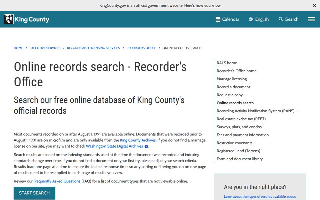
The county index is a document-finding tool. Follow the recorded instrument itself when the question is who conveyed the parcel, when it was recorded, or what legal description it names.
Washington Street Index Search Fields
The King County Landmark search offers distinct modes for name, parcel, legal description, and instrument details. Its actual choices are useful when an address search returns no deed or when a common name needs a date, document, or parcel filter. Other Washington counties may use a different index and field set.
The portal's search screen shows the available options and accepts the name as last name, comma, first name.
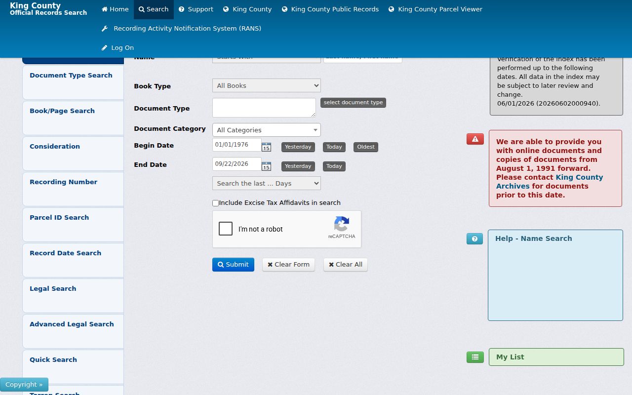
Search results open document details and an image when available. The index is free. King County accepts copy requests online, by phone, mail, and at the Seattle recorder counter. Uncertified copies can print immediately online; certified copies are mailed within five business days. The recorder's copy request form lists the information needed for mailed orders.
| Landmark Search Choice | Search Type | Use and Format |
|---|---|---|
| Search by Name | Name mode | Enter last name, comma, first name; grantor and grantee roles appear in details. |
| Search by Parcel | Parcel mode | Use the first ten digits in Starts With; parcel mode reaches 1997 to current. |
| Legal | Legal mode | Search survey, plat, or condominium; an advanced legal option appears after choosing Legal. |
| Document Type | Category | Choose deeds, mortgages, liens, plats, easements, releases, or reconveyances where offered. |
| Book and Page | Paired text | Use a known book and page citation. |
| Consideration | Numeric or text | Search a recorded selling-price or consideration field where available. |
| Recording Date | Date or range | A narrow range can reduce same-name results. |
| Recording Number | Text | Search a known instrument or recording number. |
| Legal Description | Text | Enter the legal description; survey, plat, or condo options may be available. |
| Torrens Number | Text | Use a registered-land reference when the record has one. |
| Start Search | Button | Runs the selected search mode. |
| Document line item | Result link | Opens the document detail and image when available. |
| Add to Cart or Log On | Copy controls | Opens the account and payment path for copies. |
Seattle Permits in a Washington Street Search
Permit history adds dates and project context, not a household roster. Seattle's Permit and Site History Research Tool accepts an address or map selection, then links to site characteristics, zoning and land-use overlays, assessor data, permit tracking, historic documents, and active projects. The current Seattle Services Portal covers permit activity and project documents from 2005 onward. Its record search can narrow by record type, status, date, or address range.
For a Seattle address, Seattle's project research instructions explain how to use the address and map tools and where older material moves next.
Scanned permit material reaches approximately 1894 to 1970. Permits from 1970 to 2004 are on microfiche, with some roll-film exceptions. The electronic document library includes permit and inspection material from 2005 onward. Approved construction plans for many recent permits require an individual written request to the department; some sensitive facilities are not available. The date an old scan was uploaded is not necessarily the date of the underlying permit.
Other Washington cities and counties keep their own permit and code portals, counters, phone contacts, and public-records request routes. Use Seattle's date ranges only for Seattle. For another address, ask the local building or planning department about historic paper, microfilm, and online coverage.
Washington Voter Records by Street
VoteWA is for a voter to check their own registration. It asks for first name, last name, and date of birth that match the registration. It is not an open search of everyone on a street. Washington has no party-preference field, and a vote-history entry shows whether an eligible voter took part in an election, not how the person voted. The VoteWA portal serves the individual registrant.
Public current lists and poll books are available through the state or county elections office under chapter 29A.08 RCW. The statewide voter database extract is requested through a form, is updated monthly, and may take up to five business days to fulfill. Public fields can include name, address, year of birth, voting history, precinct or district, and status. Full birth date, driver's-license number, Social Security fragments, signature image, registration source, and protected voter information are not for ordinary public use. A voter list also omits people who are not registered and participants protected by the Address Confidentiality Program.
Ask the county elections office about a current list, public counter, reproduction cost, and older poll books. A county public-records request can reach existing election records. Keep a narrow, lawful purpose; state law bars commercial solicitation from voter lists.
Historical Washington Street Occupants
For earlier residents, a street or reverse directory can bridge the years between deeds. The Washington State Library city-directory page describes general city and county directory coverage from 1890 to the present across 35 counties and 300 cities, with city-specific gaps. The Library of Congress guide covers many United States city directories from 1861 to 1960 and explains how street and reverse sections differ. A directory may show an adult resident, a business, a telephone listing, or a household notation. It may not list every member of a household, so use a dated street directory alongside other records.
The State Library's Tumwater facility no longer offers ordinary walk-in access. Its current directory page directs researchers to limited Thursday appointments, 1:00 to 4:00 p.m., arranged by email. Local libraries, archives, and historical societies can hold other runs. The catalog is an inventory, so ask a librarian to check the exact city, year, street, and reverse-directory type. The Washington city directory page describes collection use and entry reading.
Federal census records through 1950 are public under the 72-year release rule. Census and directory dates do not always align: a directory may have been canvassed at a different time, and it may include boarders or businesses that the census records differently. Pair them by address and year, then check whether the building number or street label changed.
Washington Street Names and Plats
Washington has no single statewide register of every street renumbering or address change. City limits, county lines, postal names, annexations, road vacations, new plats, and unit numbers can all make a historical address hard to match. A street name alone is not a title key. Carry the parcel number, lot and block, subdivision, quarter-section reference, or other legal description through the search, and compare older plats with the current county map.
Territorial government began in 1853 and statehood followed in 1889, while Washington counties were created at different times. A record may use a county or place name that no longer matches a modern address. Check the official county-admission history, regional archive holdings, old plats, Sanborn maps, city engineering records, and a directory street index before deciding that a record is absent.
This is a useful comparison point: King County's online deed index generally starts in 1991, while Seattle's scanned permit material reaches back to about 1894. The two dates answer different questions and apply to different custodians. A permit can date a building project, but a recorded deed is still the source for a transfer of land.
Washington Street Record Access
Washington's statewide starting point is the Treasurer's directory of county assessors and treasurers. Select the county where the parcel lies, then find its auditor or recorder, assessor, GIS, elections office, and local permit department. A county may offer a public terminal, phone help, mail request, online search, or public-records request. Historical books may instead be held by a county archive, regional State Archives branch, or local library. The State Archives Digital Archives search also covers selected transferred county series.
For a Washington Public Records Act request, describe the existing record, office, address or parcel, record type, and useful date range. An agency's initial response is due within five business days; it may provide records, give an estimate, ask for clarification, or deny with a cited exemption. The agency need not create a new list or analysis. If a portal does not show an older item, ask the custodian whether it exists on paper, microfilm, or in a transferred series. The Attorney General's record-copy scam alert explains why requests should go to the official custodian.
Keep the county, portal, search date, exact terms, and result limit with every note. That record of method helps separate a true absence from a name spelling, boundary, parcel, indexing, or imaging gap.
Privacy Limits on a Washington Street Search
A parcel map shows land and tax fields, not a private household list. The owner or taxpayer may live elsewhere, and one parcel may contain several units. Permit applicants may be contractors or agents. Voter records include only eligible registered voters in the public field set; protected voters are left out. Utility customer lists are not a normal public street source, and driver record information is restricted by privacy law. Washington's Address Confidentiality Program protects participant information in new state and local records, though it does not erase older records.
Lawful use. Washington records can support personal, family, property, and civic research. Public access does not permit tracking, threatening, or harassing a person; use a custodian's official correction or safety process when a record raises a concern.